

Bataan: Where Armies Ended and Survival Began
- Ray Via II

- Apr 25
- 8 min read

On April 9, 1942, the battle for the Bataan Peninsula ended, not with a dramatic military move, but because the defenders were simply worn out. Months of fighting, illness, and hunger had left Douglas MacArthur’s troops much weaker. Major General Edward King Jr. surrendered to avoid total destruction. Still, thousands died in the aftermath.
By April, the defenders of Bataan no longer acted as a single army. What remained were scattered groups of American regulars, Philippine Scouts, and new Filipino divisions, stretched along a failing line from Bagac to Orion. On the west side, I Corps units, such as the 1st and 91st Philippine Divisions, were already breaking apart. Hunger had weakened them badly. Food was almost gone. Units that once held their ground now moved in small, uncoordinated groups, retreating south.

On the east side, along the Orion line, II Corps units like the 11th, 21st, and 41st Philippine Divisions managed to stay together a bit longer, but their fate was the same. Japanese forces, including the 65th Brigade and 16th Division with artillery and light tanks, pushed harder each day. The defenders ran low on ammunition, and diseases like malaria and dysentery took a toll. These units didn’t fall all at once. Instead, they slowly broke into smaller groups until the surrender order reached them, whether they were still in position or moving south.
The defenders used a mix of equipment that showed both planning and desperation. American troops had M1 Garand rifles, Browning Automatic Rifles, and M1917 and M1919 machine guns. Their artillery used 75mm field guns and 105mm howitzers, but they often ran out of shells. The Provisional Tank Group used M3 Stuart tanks until they ran out of fuel. Filipino units mostly had older Springfield rifles and a few automatic weapons, and their supply lines had already collapsed.
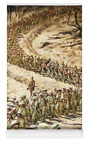
At the southern tip of the peninsula, near Mariveles, the last organized American formations gathered. The Philippine Division, including the 31st Infantry Regiment and the Scout regiments, maintained discipline even as the situation around them disintegrated. The 26th Cavalry Regiment, which had made one of the last horse-mounted charges in U.S. history just months before, had already killed its horses for food and was now fighting on foot. When their tanks ran out of fuel, crews from the Provisional Tank Group destroyed them and joined the infantry. These units still had some sense of identity at the time of surrender, but that faded within days of becoming prisoners. Japanese planners had expected perhaps 25,000 captives. Instead, they faced roughly 76,000. The force included infantry regiments, engineers, and logistical elements already stretched thin by the campaign. There were no food stockpiles, no organized transport system, and no medical infrastructure capable of supporting such a mass. The solution was immediate and brutal. Move the prisoners north on foot.
The march started under intense heat. Prisoners formed into uneven columns, often mixed with men from different units. The route was about sixty-five miles, running from Mariveles through Balanga and San Fernando, before survivors were put on trains to Camp O'Donnell. Japanese guards, mostly regular infantry, kept the prisoners moving with rifle butts, bayonets, and sometimes pistols. There was no organized system of control. Guards worked in small groups and primarily forced the prisoners forward.

Divisions and regiments disappeared, leaving only a long line of men.
Soldiers like Glenn Frazier were already weak from months of fighting before the march even started. His story was similar to those in the 31st Infantry and the broken Philippine divisions. The march didn’t move smoothly. It happened in stages. At first, people kept moving, hoping they could last. Then the column slowed, and order broke down. Guards became more violent as the pace dropped. Soon, just staying on your feet was all that mattered.
At first, groups that surrendered together managed to keep some order. But that didn’t last. The fast pace, lack of water, and harsh treatment by the guards quickly broke down any sense of organization. Frazier later said there was only one rule for survival: keep moving. Anyone who stopped, even for a moment, often vanished along the road. It didn’t matter what unit, rank, or nationality you were. Divisions and regiments no longer mattered. All that was left was the road, the heat, and the struggle to take the next step. Filipino soldiers, who made up most of the prisoners, suffered the most. Many started the campaign with fewer supplies and had gone without for longer before surrendering. Their high death rate during the march shows this. Estimates say between 5,000 and 10,000 Filipinos died, compared to about 600 to 1,000 Americans. These numbers are only rough guesses, since the Japanese kept few records and many bodies were left behind.
The ordeal didn’t end with the march. At Camp O’Donnell, survival was still uncertain. Disease spread quickly in the crowded camp, and food was still hard to find. Thousands more died in the following weeks, especially among Filipino prisoners. Survivors like Frazier lived through even more hardship after Bataan, as their captivity continued.

Compared to other Japanese wartime atrocities, the Bataan Death March stands out in its own way. It was not as openly systematic as the Nanjing Massacre. It did not last for years, as did the forced labor on the Burma Railway. It was not as deadly as the Sandakan Death Marches. Instead, Bataan shows how fast a military system can fall apart when supplies run out, and discipline breaks down.
The Japanese command did not plan for the care of so many prisoners. They did not control the guards well once the march started. Cultural views on surrender meant there was little reason to protect the prisoners. There was no single order to kill, but the system made death unavoidable.
At the unit level, a clear pattern emerges. Groups that surrendered together lost their unity within days. Broken units suffered worse and earlier losses. Once the march started, command structures no longer mattered. All that was left were individuals heading north, where survival depended on endurance and luck.
The Bataan Death March was more than just an atrocity. It was the last part of a campaign marked by exhaustion, carried out by an army unready for victory, and suffered by men who lost their identities as soldiers as soon as the march began.

The Road Through the Mountains
The story on the map starts not with the march, but with the land itself.
Bataan rises from the sea as a line of mountains, tough and unyielding, splitting the peninsula in half. Mount Natib stands in the north, its ridges stretching out like fingers that break up formations and block roads. In the south, Mount Bataan marks the end, leaving only narrow coastal plains for movement. The land between these mountains shapes everything that happens next. Armies cannot move freely here. They bunch together, slow down, and when they break, they retreat along the few remaining roads.
On the western side, the land slopes down toward Bagac and the sea. This area belonged to I Corps, where the 1st and 91st Philippine Divisions fought on ground that made it hard to stay together or get help. By April, hunger had done what the Japanese could not finish. Units broke apart on the hills and trails, losing touch with one another and their leaders, until surrender was not a decision but simply the admission of what had already happened. Near Bagac and Moron, these groups ceased to be organized units.
East of the mountains, the land opens up a bit. The Orion line runs along a more open path, with roads linking Pilar, Orion, and the southern coastal routes. II Corps managed to hold out here longer. The 41st, 11th, and 21st Philippine Divisions fought on ground that allowed some order, some movement, and a chance to defend. But the map makes it clear: there is no depth to this position. Once the line breaks, the only way out is south.
This movement starts even before every unit hears the surrender order. It begins as a withdrawal, a shift in position, a final attempt to stay organized. But the mountains close behind, and the roads ahead become crowded with men. The divisions that once spread across the peninsula now squeeze into one narrow path. The map makes it clear: everything heads toward Mariveles.
At the southern tip, the land narrows to its end. Here, the last organized groups come together. The Philippine Division, with the 31st Infantry Regiment and the Scout regiments, arrives still in formation. The 26th Cavalry Regiment comes without horses, having eaten them to survive. Tank crews leave their vehicles behind on the Pilar Road, destroying what they cannot take. These units still have their names, still follow orders, and still look like the force that once defended the line.
But this does not last.
The red line on the map starts at Mariveles and heads north, crossing the same land that caused the collapse. It does not twist through the mountains because it cannot. It follows the roads on the eastern plain, since there is no other way to move so many men. This route was not chosen for speed or kindness. It was simply the only way.
The march begins as a movement. Columns form unevenly, mixing men from different divisions, commands, and parts of the battlefield. The map shows a single line, but in reality, it is a series of broken groups, joining and splitting, slowing down and speeding up. As the route goes through Balanga, the pressure increases. There is no water except what can be found in ditches or streams. The road becomes a place where men start to fall behind, and falling behind can be deadly.
North of Balanga, the terrain flattens slightly, but the land becomes even flatter, and the situation worsens. The path narrows to a single route. The mountains are still to the west, impossible to cross, and unchanging. To the east, the coast gives no help. The march becomes a funnel, forcing everyone forward along the same path. walked. His experience fits the map exactly. The phases he described, movement, slowing, and collapse, mirror the terrain itself. Where the road constricts, the column slows. Where water disappears, men weaken. Where the pace falters, violence follows. The geography does not merely frame the march. It shapes it.
At San Fernando, the line breaks again, but not into freedom—only into tighter spaces. Railcars take over where the road ends, cramming men into places never meant for them. The map resumes, showing the last move north to Capas and Camp O'Donnell. Even here, the land still matters. The last part is short, but for those who make it, it comes after they have lost everything.
The surrender points marked on the map tell one story. They show where divisions ended: Bagac, Orion, Pilar, and Mariveles. These are places where units stopped working as units. The red path tells a different story. It shows how those men were forced into a single line, losing their formation, rank, and identity.
Between these two layers, the surrender points and the march route, the true meaning of Bataan appears. The mountains caused the collapse. The roads carried the results. At the beginning, there was no way out except forward.
Bibliography — The Bataan Death March
Primary Sources (Firsthand Accounts)
Glenn Frazier. Hell’s Guest. Rev. ed. Bloomington, IN: AuthorHouse, 2010.
Lester I. Tenney. My Hitch in Hell: The Bataan Death March. Washington, DC: Brassey’s, 1995.
John E. Olson. O'Donnell: Andersonville of the Pacific. New York: Fordham University Press, 1985.
Official and Government Histories
United States Army Center of Military History. The Fall of the Philippines. Washington, DC: U.S. Government Printing Office, 1953.
U.S. War Department. Report of the Commanding General, USAFFE. Washington, DC, 1946.
International Military Tribunal for the Far East. Judgment and Trial Records. Tokyo, 1948.
Scholarly Works
Stanley L. Falk. Bataan: The March of Death. New York: W.W. Norton, 1962.
Donald Knox. Death March: The Survivors of Bataan. San Diego: Harcourt Brace, 1981.
James H. Willbanks. Bataan: A Military History. Lexington: University Press of Kentucky, 2001.
Kevin C. Murphy. Inside the Bataan Death March: Defeat, Travail, and Memory. Jefferson, NC: McFarland, 2014.
Comparative Context (Japanese Atrocities)
Iris Chang. The Rape of Nanking. New York: Basic Books, 1997.
Hugh T. Torrens. The Japanese Thrust into Burma. London: HMSO, 1959.
The Railway Man. London: Jonathan Cape, 1995.


Comments